
Sunday June 2 - Wednesday June 5th
Took off from Capitol Reef, drove through Hanksville, turned right on Hwy 95 which we followed south across the Colorado River, past the White Canyon, past Natural Bridges and headed toward Blanding.
 |
| Crossing the Colorado River |
 |
| Views of the Colorado River |
 |
| The White Canyon - a fascinating canyon just east of Natural Bridges |
 |
| White Canyon - another place to explore |
At the Blue Mountain RV Park, where we stayed, we were assigned Site #5 which had a little grassy patch and a small tree. That evening, we did our laundry and ate a tasty dinner out at the Homestead Steakhouse in Blanding. This was a nice little park, with an authentic trading post, big hot showers and decent-sized laundry facilities. Its biggest benefit was its location near a number of national parks that we wanted to visit on this trip including: Hovenweep, Natural Bridges and the southern section of Canyonlands.
 |
| Our cozy little camping spot at the Blue Mountain RV Park. |
Natural Bridgeso
On Monday, June 3rd, we visited Natural Bridges National Monument. The park is small, the camping sites are ideal for small tents and tent trailers only, and the overlook sites look down into the canyon and the natural bridges there. It's a beautiful little park and we had always enjoyed visiting there when we were still camping in tents. For this trip, we wanted to do a little hiking in the canyon, so we hiked down to the Owachomo Bridge with the intention of hiking back up the canyon to see several of the other natural bridges up close, but unfortunately, our efforts were thwarted. Any animal trails or other human-made trails that we found to follow were taped off or blocked with trees. We went back and forth attempting to located the trail up the canyon - to no success. So we finally gave up, ate our lunch, then drove out of the park. We remember that years ago, following the trail had been easy and we had basically hiked the entire canyon, but the NPS has changed that now - very likely for visitor safety. We were frustrated, but we are old-timers and like to have things kept the same as before. We don't adapt well to change!
We next decided to explore the Cedar Mesa area to find some trails to hike there. We had heard from our neighbors at the RV park that the Cedar Mesa is well-known locally for its multiple cliff dwellings and interesting trails. We were advised to pick up a detailed trail map at the Kane Gulch National Forest Service office. Unfortunately, after our Natural Bridges fiasco, by the time we stopped at the Kane Gulch - Cedar Mesa Ranger Station on Hwy 261 to get a hiking map, it was closed for the day (open only from 8 to 12 a.m.). Poor planning on our part. This is definitely a place to remember and return to in the future. We like to discover new, less crowded places and this is one we will add to our list.
Moki Dugway
Our surprise gift for the day was Moki (Moqui?) Dugway. We hadn't done our research and knew absolutely nothing about it - only that pictures of it reflected stunning views of the Monument Valley below. From Kane Gulch, we headed there on Hwy 261 and when at Muley Point, the road turned to gravel and dirt, we suddenly started down a very steep switch-back road headed straight down the hill toward the Valley of the Gods. It quickly became a one-lane very narrow road with no shoulders and no guard rail, The mountain on the driver's side curved outward over our truck (which was in the outside cliff-edge lane). The cliff on the passenger side dropped straight down several thousand feet - with NO shoulder. OMG! The gravel provided very little purchase for our tires as we took the sharp hair-pin turns and Ernie had to battle for room on the road to pass the huge gravel trucks that were lumbering toward us up the hill at top speed (they had to accelerate to keep up enough speed to make it to the top). These huge gravel trucks were big and had to weave in and out to avoid hitting the rocky overhangs above. Tioga Pass is nothing compared to this road! I let out a number of squeeks and Ernie white-knuckled it all the way down! Thank heavens he is such a good driver. Later, when we finally saw the description, we gasped:
"The Moki Dugway is a staggering, switchback road carved into the face of the cliff edge of Cedar Mesa. Muley Point offers stunning views of Monument Valley
If you have a death-wish or are an adrenaline junkie - take this road. If not, watch a video and laugh. We definitely will not make this mistake again! I don't have many pictures, because most are a mess - totally blurred. I was terrified! There was also zero opportunity to pull over off the road. NOPE; never again! Following is an aerial view from the internet - the best I can do to provide a visual. Remember - it's all a single lane road for 2-way traffic, at an 11 percent grade and all dirt and gravel with sharp switchbacks. A thrill. BTW the term - Moki Dugway - comes from a Native American name (Moqui) and Dugway (from when trails for horse-drawn wagons had a track for the two wagon wheels dug out of the roadway so that the wheels would not slip out on steep inclines). Similar to Xcountry ski tracks. That was in the past, though. These tracks no longer exist.
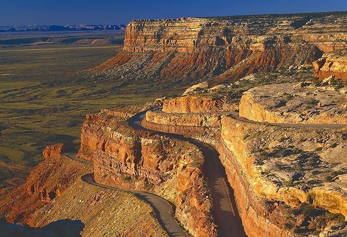
So, our best advice - plan well ahead. Just because a vista is spectacular, doesn't mean it's safe or even sane.
Following are a few pictures that we could salvage:
 |
| A quick peek down over the edge to Monument Valley |
 |
| The road twisting back on itself |
 |
| More Valley view - if you dare! |
 |
| Finally on flat land! Monument Valley |
 |
| Looking back on the colorful Monument Valley |
We were thrilled to reach the bottom. Next time, I'll stick to the ferris wheel!
BTW, MJ and Chris - you are sooooo lucky we did not have this on our list in 2014!
Canyonlands - Southern section with the NeedlesBTW, MJ and Chris - you are sooooo lucky we did not have this on our list in 2014!
We haven't spent much time down in Canyonlands, particularly in the southern end of the park and we had a wonderful opportunity to drive there from Blanding. Being in the southern section of the park, we were actually down in the canyons and we could look up to the mesas and needles of rock towering above. This was a totally different perspective from what we experienced on our other trips and the colors and light changes on the rock faces were spectacular.
 |
| Newspaper Rock at Indian Creek. Notice the horse - which dates this individual drawing as post - Spanish visitation - a much later date |

 |
| Canyon characters! |
 |
| My faithful travel partner! |

 |
| The Needles |
Hovenweep
Hovenweep is a small National Monument located about an hours drive east from Blanding on a somewhat rough dirt road in the middle of the Navajo reservation. The community was built by the Ancestral Puebloans aproximately in 750 AD and remains of the structures are visible along the top of and down in a small narrow canyon. These ancient people were related to the Chacoan culture in New Mexico. We were able to take a short hike in and around the area. The visitor's center is an excellent source for books on the area. We were quite surprised that these structures blended so well into the topography and were not easily visible from a fairly short distance. These people would not be discovered easily!
 |
| Numerous structures and partial buildings are still standing, even after 1000 years and tons of weather. |


The Edge of the Cedars State Park and Museum
Just on the edge of the Blanding township, ancient dwellings built by the Ancestral Puebloans remain. A wonderful little museum is located there and it provides an excellent overview of the migration and movement of these early Americans along with displays of numerous artifacts of weavings, pottery and clothing. This is another favorite small museum of ours.
 |
| An amazing display of black on white and red on black pottery were there. |
 |
| A friend for Amelia and Ava |
 |
| Museum Garden Art. Coming up for a breath of fresh air! |
 |
| Colorful Macaw feather sash sewn by Ancient Puebloans - cir 1000 AD. Feathers from Central/South America were part of their trade tradition. |
 |
| A blanket made from turkey feathers. They raised turkeys and then wove these blankets for warmth using these feathers. Another take on down. |
No comments:
Post a Comment