Pages

Thursday, June 20, 2019

Capitol Reef - Our Favorite Wonderland

Wed 5/29 - Sun 6/2
Capitol Reef - Wonderland RV Park


In order to avoid a 10,000 ft  elevation pass and the associated snow, we drove from Bryce to Capitol Reef following the Sevier River and Hwy 22 toward Antimony. The valley, framed by snow-capped peaks, was lovely. We turned right at the Otter Creek Reservoir - a small state park, then headed toward Torrey following Hwy 62, then 24. This was a much quieter, more relaxing route than the more direct, snowy route over the mountains. 

In the early afternoon, we arrived at the Wonderland RV campground in Torry - a private RV park, since we had been unable to secure a campsite at Fruita in December, six months before.  Everything had been booked out and this was our next best choice. Our campsite was perfect - located right next to the "Sheep Camp" (an authentic old sheep tender's wagon) and our ranch view provided close encounters with the local cows and a family of ducks.

Sleepy cows

Our Sheep Camp
Capitol Reef continues to be one of our favorite parks. The uplifted sandstone rock, the multiple changing colors, the waterpocket fold, and the twisting canyons provide unlimited entertainment and hiking opportunities. Following is just a sampling of the places we visited and enjoyed the days we were there:  

The Gifford House Bakery and  Original Mormon Homestead

"Ole Timey" Treasures

Picnic area - We enjoyed the cherry pie from the Gifford House here

Fruita Campground fruit trees contrasted against the rock walls.
Hiking up to Navajo Knobs from the river - 9.5 RT miles.
Putting my new hip to the test!


Sandstone mushroom art - looks a bit like cow-pies!

Overhead View of the Fruita campground from the Navajo Knobs trail

Fantastical Formations

Trail view of water action on Sandstone

After the roads appeared to have dried out and the weather stabilized, we headed up to the Dixie National Forest and the Anasazi Museum and ruins to view their artifacts, then drove a portion of the Burr Trail road - which started just south of the museum and entered the Escalante Staircase park, then Capitol Reef. We were warned by the Park Service to avoid the non-paved portions traveling alongside the Waterpocket fold and along the cliffs. Sand and mud are extremely slippery when wet and the local rescue vehicles will not venture out to save a careless tourist that gets stuck. In addition, lack of cell service ensures that foolish adventurers have a true independent adventure in the wild. So we drove the canyon to the end of the pavement, then did a quick U-turn.

Burr Trail Rd South of Capitol Reef - part of the Escalante Staircase
Tall Canyon Walls
View out toward the Waterpocket Fold from Burr Trail
More Burr Trail Formations


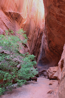
Entrance to a slot canyon off the Burr Trail Rd.

Slot Canyon magic


Slot Canyon Grand Entrance & Exit

Tacos at the Anasazi Museum were a surprise treat! 
The owner was from Nevada City!
We could spend weeks exploring this fascinating area!

Our next destination was Blanding, Utah - which would provide easy access to the Canyonlands, Natural Bridges and Hovenweep parks. Because of overcrowding and excessive tourism in Arches we had decided to skip that park this year. We had camped there numerous times while we were young and when it was still a relatively new park and was virtually unknown, with few visitors. It is time for us to let the rest of the world to see it. Yes, we are a bit crowd-averse.

Wednesday, June 19, 2019

Bryce Canyon National Park

Mon 5/27 - Wed 5/29
Bryce Canyon National Park - Ruby's Campground

Our drive from Navajo National Monument to Bryce Canyon National Park, through spectacular country, was through periodic rain and snow. As we threaded out way up through Red Canyon, snow began to fall, but the road remained clear. We need to put Red Canyon on our bucket list - it looks beautiful!
Navajo Country - heading north to Bryce

Thunderheads were building to the north - right where we were headed!

Red Canyon - added to our list for the future

We set up camp in Ruby's Campground site #98, near the laundry and the showers. The sites were somewhat close, but under the trees, which was nice. After having lunch, we did our laundry, finished some housekeeping, then we drove over Ruby's Cowboy Buffet for dinner. I had a salad and Ernie had the full buffet dinner. Good food, so we were pleased.

On Tuesday, we toured Bryce. Lots of tourists from all over the world, were enjoying the park and it was crowded. Because of the snow and sleet, we toured the sites, took photos, but did little else, because the trails were covered with snow and mud. That night we, again had dinner at Ruby's Cowboy buffet.

Canyon Vistas - looking out toward Glen Canyon and beyond
More views


Arch in Bryce

Thunderheads threatening


On Wednesday, we headed to Capitol Reef - Wonderland RV Park (we had been unable to obtain a camping reservation for Fruita CG in December, since the demand this year is so high - disappointing, but that's what's happening to the national parks now.) They are being well-loved.

Snowy Sitzplatz

Tuesday, June 18, 2019

Navajo National Monument - Betataken Cliff Dwelling

Thursday May 23 - Sunday May 26th - Navajo National Monument
Sunset View Campground

On Thursday May 23rd, we checked out of our Jacob Lake Inn room and drove from there past the Vermillion Cliffs, toward the Navajo National Monument, home of the Betataken and Keet Seel Cliff Dwellings. We crossed over the Navajo Bridge and the very muddy, but rushing Colorado River and drove into the Native American reservation area. It was raining and hailing, but periodic glimpses of the sun through the black clouds gave promise of blue sky days to come. A view of Navajo Mountain in the distance followed along with us as we drove.

Crossing the muddy Colorado River
The famous Navajo Bridge
Our new camp spot - a view and warmth from the sun!
The deep canyon where the Betataken and Keet Seel cliff 
dwellings are accessible to hikers.
The Sunset View Campground road in the monument was paved! We were fortunate to avoid that sticky red clay mud! We located a perfect site #13 at the top of the hill, providing maximum sun and a great view and we set up camp there. We were coming into Memorial day weekend, but the campground was not yet crowded - thanks to it being virtually unknown to visitors from outside the area.
Our sunset canyon view
The view of Betataken from the top of the canyon
When we were in our 20's, we had visited the area and loved it and always knew we wanted to return here to hike down into the valley to see the cliff dwellings. This was a bucket list item, especially for me since I now had a new hip and wanted to test it out. The Betataken cliff dwelling was inhabited by the Ancient Puebloans (Anazasi) from approximately 1000 AD for only about 100 years. They raised crops in the valleys and relied on the rivers in the canyons for water. They moved out, most heading toward the Rio Grande river and other sites south, due, likely, to drought and dwindling food supplies. The Navajo, Zuni, and Hopi now living in the 4-corners area are thought to be their descendents.

On Saturday 5/25, we joined 13 other hikers and a National Park Guide on a 5 mile RT hike straight down into the cliff dwelling site and back up. The trek down was on a trail partly carved into the face of the rock on steps created by Navajo Nation members in the 1970's.  It was a little bit dicey for me due to the steep drop down and the slick rock face, but we both made it fine - down and back and I was proud that I had accomplished it. Ernie stuck with me, cheering me on the entire way.  Thank you! One senior hiker did have to get rescued by jeep near the top due to exhaustion, but I made it the whole way!  Yes! We were all fortunate the weather was cool and not in the 100's.
Starting the climb int the canyon
Crimson cactus blooms on the trail
Storage caches for food were discovered at the back.
Corn kernals used for seed can last up to 1000 years.

Massive cliff overhang protected them from sun and storms


Dwellings were carved from rock, bricks made of mud were 
used to build homes and food caches.

They created the bricks from local mud and stacked them using branches.
Groups of families lived together in these small dwellings.

Ready to return to the top

Most of the crowds at the park dispersed after the holiday and the little campground became deserted and quiet once again. This will always be a favorite place for us.

On Monday, 5/27 we will be driving over to Bryce. Since it sits at about 9,000 elevation, we are again expecting snow and rain and we have been watching the dark clouds and weather develop north of us for the past few days. Thank heavens we have had sun and warmth while we were here.

Heading north toward Bryce Canyon 
on our final day